
The Malago Greenway path has lots of information signs - the map above is from one of them. The Malago has been diverted, culverted and generally hacked about as Bedminster developed, and now there are 4 separate points at which it flows into the Avon: The Malago itself, a relief culvert built in the early 1800s to relieve flooding, a second bigger relief culvert built in the early 1900s after the first one didn't prevent flooding, and finally the huge "Dreadnought" Malago Storm Water Interceptor built in 1971-1974 after the first two couldn't prevent major flooding creating Lake Bedminster in 1968.
The Malago
From St. Johns Lane the Malago flows along the south side of the railway towards Bedminster station, through a short culvert under the railway, along the north side of the railway and into a culvert under Whitehouse lane, emerging in Clarke Street to flow around 2 sides of the NCP car park in Dalby Avenue and into a longer culvert that takes it along East Street, then Regent Street, under Asda's car park and finally out into the new cut by the junction of Coronation Road and St. Johns Road.

This is most easily seen from "God's Garden", just opposite the Louisiana in Cumberland Road.
The 1800s Relief Culvert
This runs from the back corner of the NCP car park in Dalby Avenue and into the new cut just east (towards Temple Meads) of Bedminster bridge.


The 1900s Relief Culvert
This runs from St Johns Lane and emerges into the new cut by the junction of Camden Road and Coronation Road. Here's the St. Johns Lane infall...


... and here's the outfall into the new cut. This is most easily seen from the riverside path accessed from a ramp in Cumberland Road just before the railway bridge, a hundred yards or thereabouts from the massive dreadnought outfall opposite the bottom of the ramp.

Dreadnought
Here's the outfall of Dreadnought into the new cut. You'll find a view of it from Cumberland Road, about 200 yards west of Gaol Ferry Bridge and down the ramp of the riverside path.

Finding the infall means a much longer walk, and introduces a new watercourse: the Pigeonhouse stream which also starts in Dundry, flows via Hartcliffe and Imperial Park and joins the Malago a little way uphill from the fire station in Hartcliffe Way. From St. Johns Lane, cross into Francis Road, follow along and cross Bedminster Road and follow the Malago Greenway through the sports ground into Marksbury Road. Turn right in Marksbury Road, then left by the bridge over the Malago onto the Greenway to Parson Street. The Malago wanders off into industrial estates here: go right along Parson street, then left into Hastings Road. This emerges into Hartcliffe Way; Turn left and the Malago appears on your left just as you reach the fire station. A couple of hundred yards further, and the Malago and Pigeonhouse stream join in a patch of woodland on the left. The Malago is culverted under Hartcliffe Way here: cross over and go into Manor Valley Woods nature reserve via Vale Lane. Follow the path for several hundred yards and you will find the dreadnought intercept.
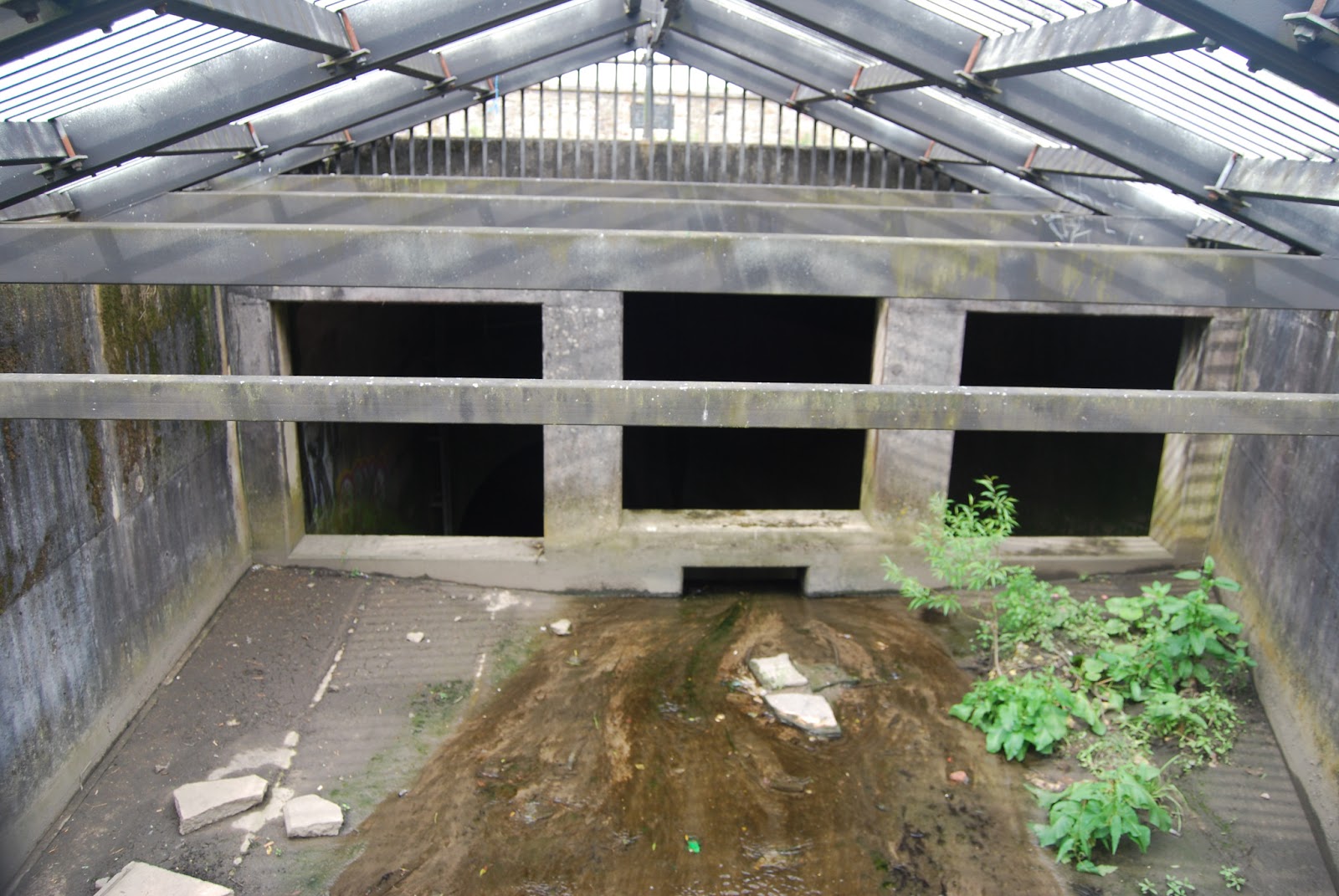

This is a large structure and the Malago vanishes completely into the storm water interceptor at this point. I think there is a small run-round culvert to take a limited amount of water to the lower Malago, but I don't know whereabouts.
The Pigeonhouse stream enters the storm water interceptor in Crox Bottom, a long way up Hartcliffe Way from Manor Woods Valley, not far from Imperial Park. Walk on the right and watch for signs to Crox Bottom. The intercept is just a few yards from Hartcliffe Way, down a fairly steep path.


Like the Malago intercept, this also appears to swallow the Pigeonhouse stream completely. There is a culvert that takes the stream under Hartcliffe Way very near this point; I don't know if there is a run-round to divert a little water into the lower Pigeonhouse stream.
Dreadnought is said to continue uphill from here, presumably to collect storm water run off from Inn's Court and parts of Hengrove that would otherwise end up in the Pigeonhouse and the lower Malago. Search for "Malago storm water interceptor" in Google to find pictures of the inside of Dreadnought.
I found this very interesting, thanks.
ReplyDelete